Every year between June and November hurricane season causes unrest for those attached to the Gulf of Mexico. It is considered the incubator for fierce hurricanes that can disrupt life for days, weeks, and even months for those who happen to be in the path of tropical cyclones that bring wind damage, rain damage, and more importantly storm surge. Those storm elements could impact SWAC football this weekend, including the Jackson State and Southern game.
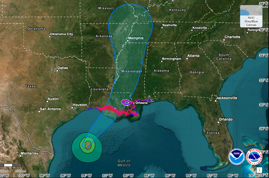
Tropical storm Francine has formed in the Gulf of Mexico near Texas, but it is moving in a northeastern pattern which will take it directly over Baton Rouge and up through Jackson, Mississippi. This weekend, the Tigers are set to host the Jaguars in a crucial SWAC matchup. It will feature two teams vying for a top spot in their respective divisions.
Francine is expected to make landfall on Wednesday and proceed up into the body of the United States. The cone of probability has both Baton Rouge and Jackson in the path. Fortunately, Francine formed closer to land in Mexico and not in the open waters where it often gains tremendous strength. Because it is forming close to the Texas coastline, its wind sheer is diminished. It is expected to reach category one status by tonight and slight possibly of elevating to category two by tomorrow.
The issues with Francine is the sea level in the area it is making landfall. Storm surge could possibly reach 10 feet with up to 12 inches of rainfall. The wind speed is estimated to peak out at 90 mph into the Louisianna coast and should be reduced to just 35 mph when it passes Jackson on Thursday.
With a 7:00PM kickoff, at Jackson State, the worst of the weather should be well past Jackson. Kickoff temperature is expected to be around 70 degrees with an 84-percent humidity index. Winds will be nominal at under three mph with a 23-percent chance of rain.

NOAA map of predicted cone of probability for Hurricane Francine
UPDATE as of Sept.11 @4:30AM: Francine crossed the threshold of wind speed to become a category 1 hurricane around 10:00PM. She is headed toward the Louisiana coastline with 90 mph winds. She will arrive early this morning making landfall and the eye wall will be over land by late afternoon. The projected path is directly over Baton Rouge with New Orleans in the path as well. By Thursday Francine will arrive in Jackson, MS with winds up to 50 mph. A dry front has prevented Francine from gaining more windspeed, but she could still reach category 2.
